



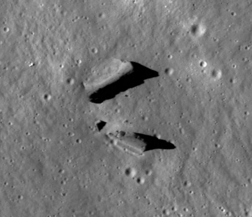
In a panoramic photograph taken from lunar orbit, two bright, sharply defined objects stood out from the otherwise subdued landscape on the floor of a crater called Paracelsus C. At the resolution available in the early 1970s, it was impossible to tell exactly what they were.
Today we can take a much closer look.
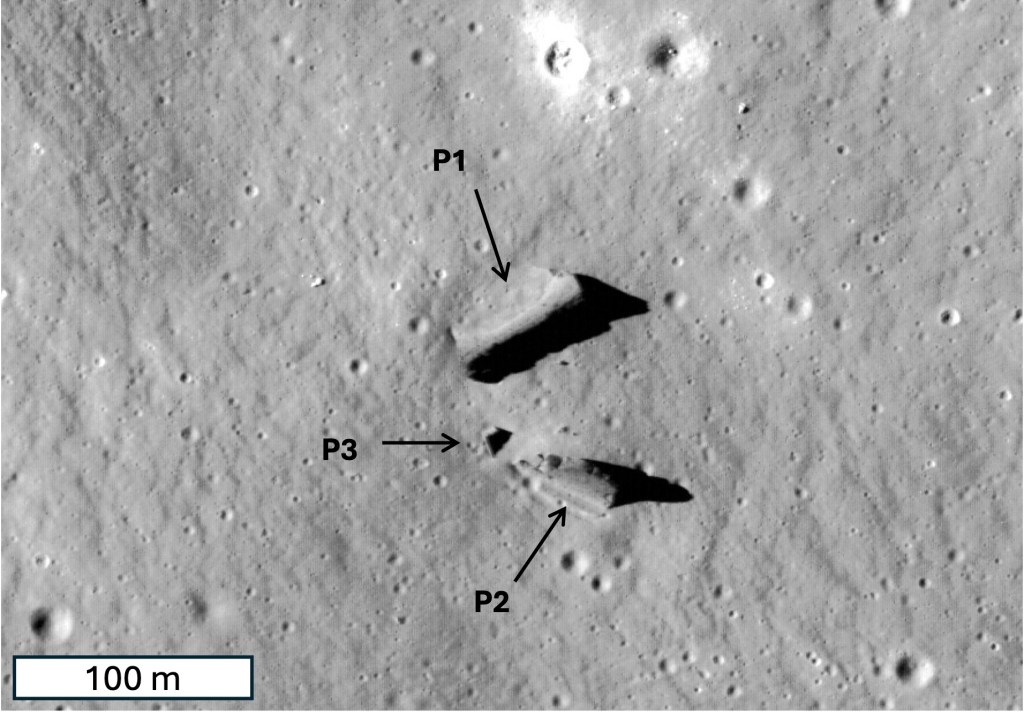
Images from NASA’s Lunar Reconnaissance Orbiter Camera, or LROC, show that the original Apollo photograph was not simply creating an illusion. The two prominent features are real, substantial pieces of lunar topography. A third, much smaller feature is also visible nearby. In our study we call them P1, P2 and P3.
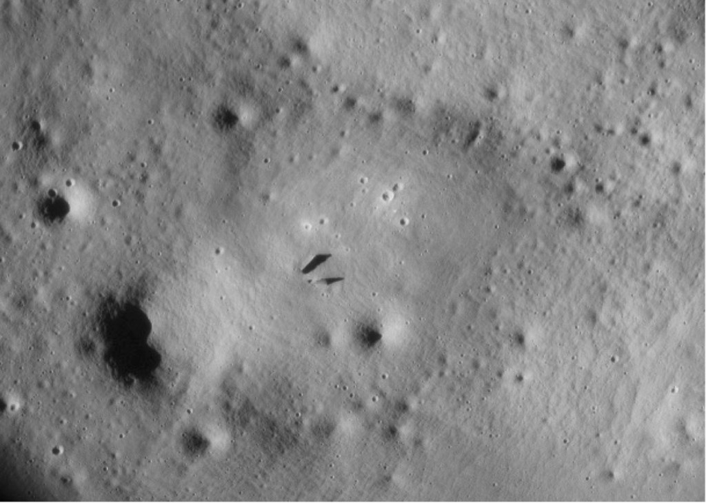
Bigger and steeper than they first appear
Paracelsus C is an ancient crater in the lunar highlands on the Moon’s far side. It lies within the enormous South Pole–Aitken basin region, one of the oldest and largest impact structures on the Moon.
The crater itself is billions of years old, and its landscape has been slowly modified by impacts, seismic shaking, the movement of lunar soil, and countless micrometeorite strikes.
Against that ancient, weathered background, P1 and P2 are surprisingly prominent.
P1 is approximately 61 meters long, 20 meters wide and 10 meters high. P2 is somewhat shorter—about 44 meters long and 22 meters wide—but nearly as high, about 10 meters. P3 is much smaller, roughly 10 meters across and less than 2 meters high.
What caught our attention was not simply their size. It was their shape.
Measurements from lunar topographic data indicate peak slopes of roughly 42–52 degrees on P1 and P2. Slopes steeper than 35 degrees are unusual in old, degraded lunar highland terrain because loose lunar material tends to move downhill rather than remain on extremely steep surfaces.
In other words, these structures retain unusually steep relief for their surroundings.
Seeing the same objects at three times of the day
One advantage of orbital imaging is that the same place can be photographed at different times of the lunar day.
We examined LROC images taken in the lunar morning, near midday and in the afternoon. Because shadows change dramatically as the Sun moves across the lunar sky, each image reveals something different.
At low Sun angles, shadows emphasize height and shape. Near midday, when shadows shrink, subtle surface textures become easier to see.
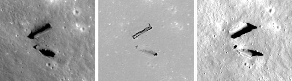
The midday image revealed details that are difficult to see at other times.
One side of P1 has a textured appearance that may represent exposed rock, while another side appears smoother and may be partially covered with lunar soil, or regolith. P2 shows a narrow textured or striated region along its upper surface.
To get a better idea of their three-dimensional form, we used the images together with reconstructed terrain height to create synthetic perspective views—as though we could fly around the structures and look at them from different directions.
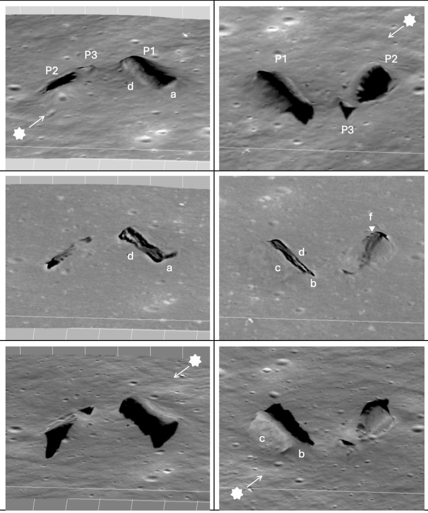
The oblique views make P1 and P2 look like actual pieces of terrain rather than bright and dark patches in a vertical satellite image.
The strange details on P2
P2 may be the most intriguing of the three.
Along its upper surface are several small circular pits. Along one side is a narrow linear depression resembling a small rille or graben—essentially a miniature groove or trench in the surface. There is also a small impact crater nearby.
The linear feature is only about 4.4 meters wide.
That matters because small-scale lunar topography does not last forever.
There is no wind or rain on the Moon, but the surface still changes. Micrometeorites continually strike it, impacts shake and redistribute material, and loose soil gradually moves downhill. Over long periods these processes tend to blur sharp features, much as diffusion smooths an initially rough surface.
We therefore asked a simple question:
How long should a feature only a few meters wide remain recognizable?
The following figures identify the small graben-like feature () and plots how its relief decreases with increasing modeled time (). The modeled terrain progressively loses relief from 1 to 128 million years ().
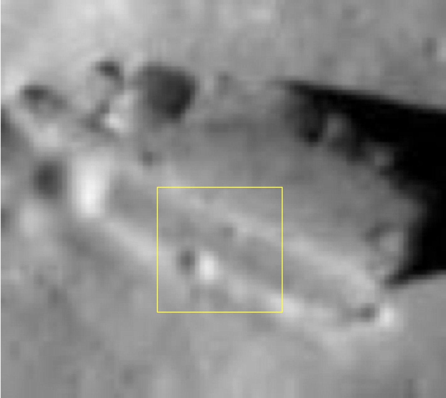
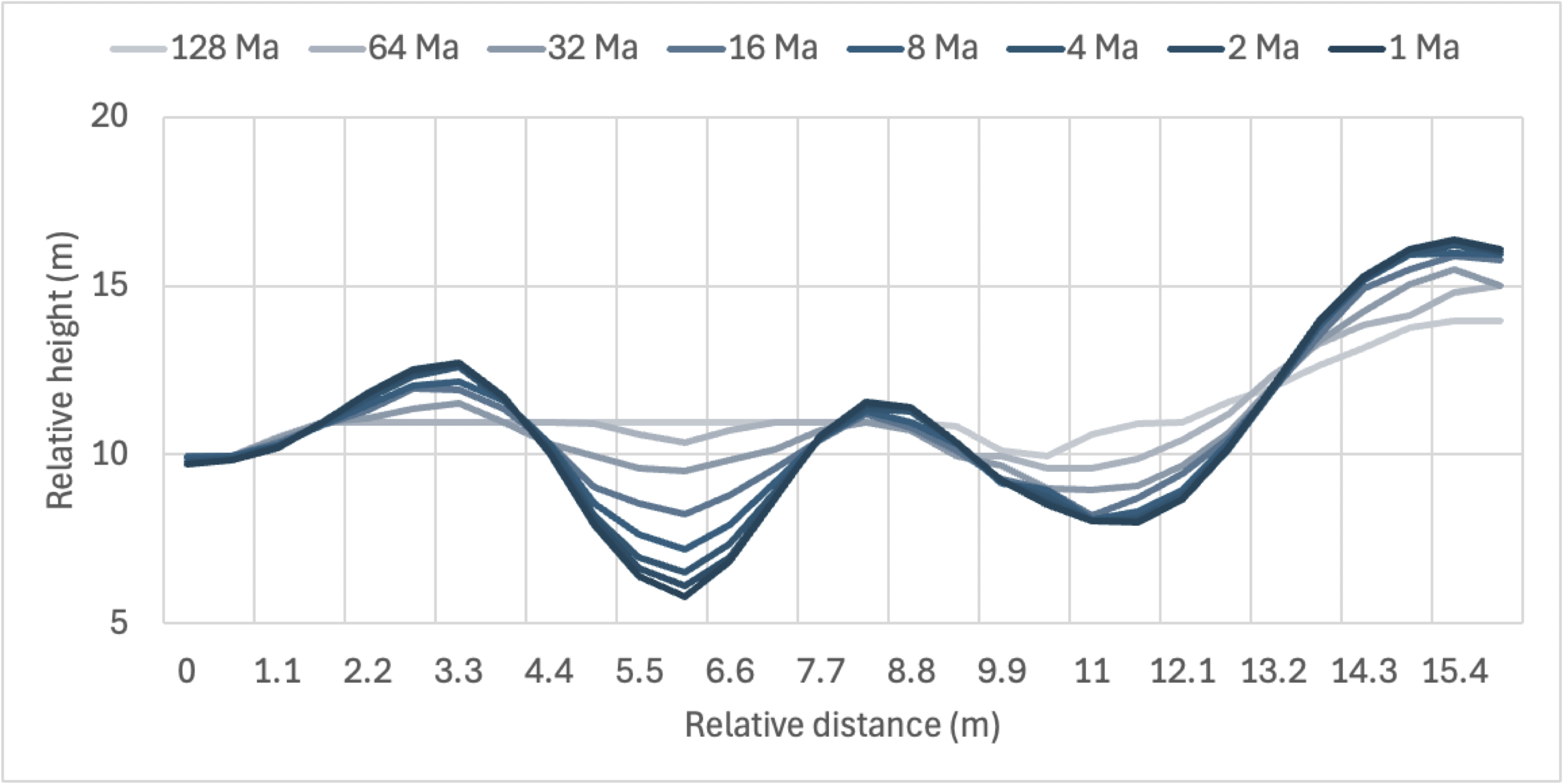
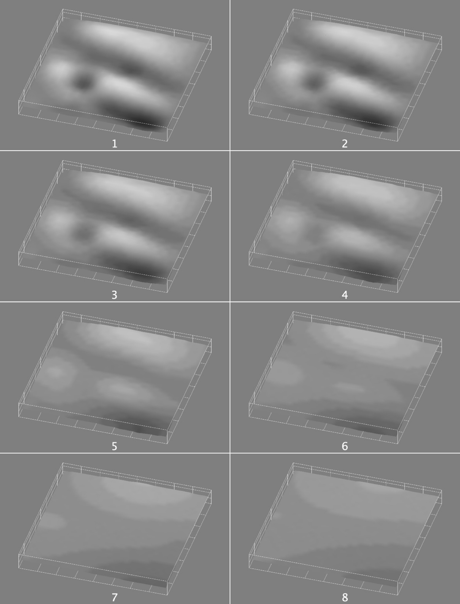
As shown above, using a standard model of lunar topographic diffusion, the reconstructed groove next to P2 becomes substantially smoothed after roughly 16 million years under the assumptions used in the study.
Sixteen million years may sound ancient in human terms, but on a Moon whose surface is measured in billions of years, it is relatively short.
An apparent age paradox
Here the story becomes more interesting.
Some observations suggest that P1 and P2 have been sitting on the lunar surface for a long time.
Lunar soil has accumulated around parts of P1. Modeling of similar deposits around lunar rocks suggests that substantial accumulations of this kind can develop over timescales of roughly 50 million years.
Spectral measurements of the surrounding area also indicate a relatively mature, space-weathered surface rather than freshly exposed material. The optical maturity measurements, known as OMAT, are lower near the features than around several nearby young craters—again suggesting prolonged exposure.
Yet the steep slopes and small-scale structure on P2 look unusually well preserved.
So we seem to have two different clocks.
One says old.
The other says remarkably well preserved.
This is not necessarily a contradiction, but it is something that any explanation for the features has to account for.
Perhaps the material is harder or more resistant than the surrounding lunar terrain. Perhaps the standard erosion model does not apply locally. Perhaps parts of the structures were exposed more recently. Or perhaps local topography has protected them.
At present, we cannot distinguish among these possibilities.
What are they made of?
We also examined mineral maps produced from data collected by Japan’s Kaguya lunar mission.
These maps are much lower in resolution than the LROC photographs, so they cannot tell us the composition of P1 or P2 themselves. They can only tell us about the broader region around them.
That limitation is important.
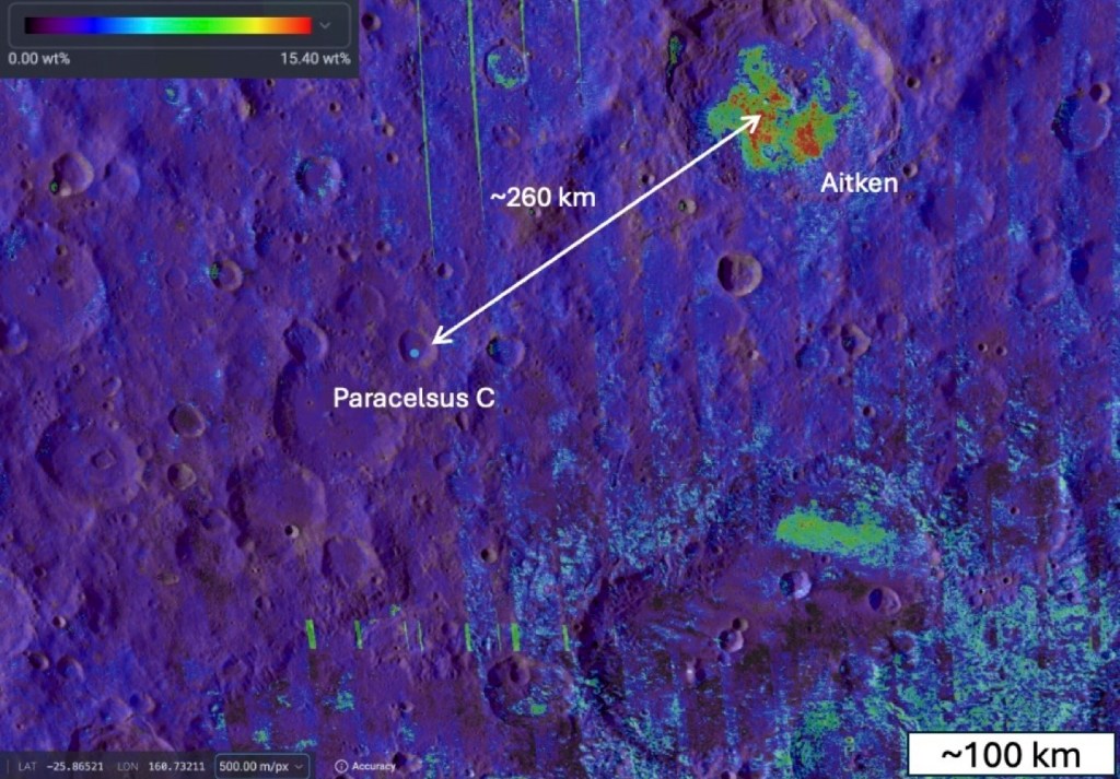
Even so, the regional composition contains an interesting clue. The area near P2 shows an elevated abundance of olivine compared with much of the nearby terrain. The measured map value near P2 reaches about 17 percent, compared with generally lower values in the surroundings, although the coarse resolution prevents us from assigning that composition directly to P2.
Olivine is relatively uncommon across this portion of the South Pole–Aitken basin. Larger concentrations occur around Aitken crater roughly 260 kilometers away.
What could P1, P2 and P3 be?
We compared the Paracelsus C features with better-understood lunar formations.
The figure below presents examples of lunar surface features. Exposed bedrock along Hadley Rille (A), at central uplift in Anaxagoras Crater (B), and in volcanic vent within the Schrödinger impact basin (C). Large boulder with spallation halo on the central peak of Tycho (D). Stratified ejecta block (E) on the far side. Smaller boulders in Paracelsus C (F) and at Apollo 17 Station 6 (G).
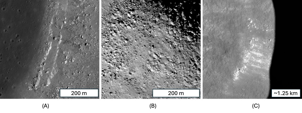
Possible natural analogs include exposed bedrock, large boulders, stratified blocks thrown out by impacts, and remnants of ancient impact melt.
Four broad possibilities emerge.
One is that P1 and P2 are enormous blocks that somehow moved downslope. But there are no visible boulder trails leading to them.
Another is that they are ejecta blocks—large pieces of rock thrown out by an ancient impact. The layered appearance of parts of P1 and P2 is consistent with this possibility.
A third possibility is exposed bedrock. This would help explain the absence of transport tracks and the apparent relationship among the three features.
Finally, they could be remnants of impact melt associated with the enormous South Pole–Aitken event. Impact melt can solidify into relatively coherent rock, potentially making it more resistant to erosion than the fragmented material surrounding it.
Each idea explains some observations, but each has problems.
No single explanation currently accounts for everything.
Are P1, P2 and P3 related?
One of the simplest but most provocative observations comes from comparing their shapes.
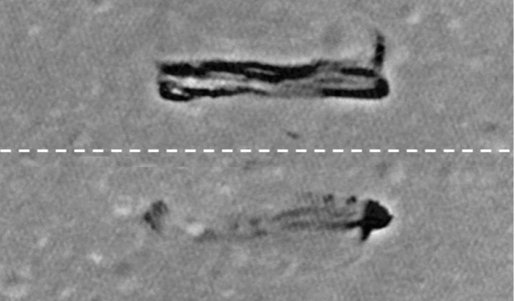
When P1 is placed above P2 and P3 and the features are rotated into the same orientation, P2 plus P3 together span approximately the same length as P1.
This does not prove that they are connected. P3 could simply be an unrelated small boulder.
But the similarity raises the possibility that all three features reflect the same underlying geological structure or process.
What we can—and cannot—say
Perhaps the most important result of this work is also the least sensational.
We still do not know exactly what P1, P2 and P3 are.
What the new analysis does establish is that they are not simply photographic artifacts or ordinary pieces of lunar terrain that disappear under closer examination.
They are measurable topographic features. The two largest are tens of meters long and roughly ten meters high. They contain unusually steep slopes. Parts of their surfaces show fine structure. They sit within mature lunar terrain, yet some of those structures appear surprisingly well preserved.
Nearby lunar boulders do not provide an obvious match, and no single formation mechanism explains all of the evidence.
The next step is therefore not speculation but better data.
Higher-resolution topographic measurements could determine the true slopes of their individual faces. Better mineralogical measurements could tell us whether the apparent compositional differences really belong to the features themselves. And higher-resolution photographs could resolve the small pits and linear structures on P2 and clarify the poorly resolved shape of P3.
The Moon still contains landscapes whose geological history we do not fully understand.
Paracelsus C appears to be one of them.
Link to Icarus Paper